
ArqueoAstur: the archaeology of fortified landscapes in Asturies
Welcome to our first community blog!
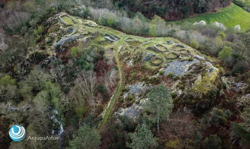
I’m thrilled to be introducing Eduardo Pérez-Fernández, archaeologist and co-founder of Arqueoastur, an online research and dissemination project focusing on the forgotten heritage assets, forts, and castles that span across the Asturian landscape. Their latest blog post focuses in on multi-phased fort El Picu San L.luis located in San Martín de Beduledo, Celón parish.
Now, take it away Eddie!

Eduardo Pérez-Fernández, archaeologist.
“Because each one of them is something more than a useless ruin ... each fortified enclosure is a unique and irreplaceable element that treasures valuable information about the cultural and historical legacy of our ancestors, towns and cities, the true sign of identity that differentiates us from the rest.” Arqueoastur, 2021
What is Arqueoastur?
Arqueoastur is a dissemination and research project to publicise and guarantee the protection of fortified enclosures in Asturias, in the North of Spain. The main objective is to educate and engage people in the study of these monuments, making them aware of the irreparable damage that archaeological heritage in general may suffer and to allow them to participate in this preservation in an easy, accessible way for all, away from the technicalities that are only understood by the few.
It is also an example of the enormous potential hillforts can offer for future enhancement strategies, not only for their historical value but also for their potential as a catalyst for economic development in disadvantaged areas.
Arqueoastur aims to be a tool that makes its archaeological heritage visible to public opinion in an easy and simple way. It is an open window into the unknown world of Asturian fortified landscapes, a meeting point from which to raise awareness, sensitize and involve the whole of society through the dissemination and online dissemination of heritage.


The Online Viewer & State of Preservation
Archaeological heritage must be visible in one way or another. With the current archaeological dissemination strategies, it is increasingly common to find online viewers that allow the consultation of heritage assets briefly. They create a link with society, which thus becomes aware of and gets involved in the complicated work of protection. When something is known it can become appreciated, and when it has already been appreciated, it begins to protect itself. That is why this viewer was born, to offer an overall view of all the hillforts documented in Asturias.
The result; more than 500 recorded files with the name and location of each site, the year of its cataloguing, who carried it out, and the date of its inclusion in the municipal Archaeological Charter and in the Inventory of Cultural Heritage of Asturias.
A map offers more than just geographic information, it shows the state of preservation in a visual and accessible way. We show this state through five colours that indicate the severity of the damage suffered and the affected surface. Based on the most recent alterations the hillforts are classified into five groups, each one represented with a colour.
The green shows all those hillforts whose surface has been affected up to 25% by human activity. They are in a regular state of preservation and have a favourable prognosis. Between 25% to 50% of the damaged surface, we can identify them with the yellow colour. Here, they are in a bad state of conservation, where the expectation of recovery is not extremely positive. However, no notable risks are recognized in the immediate future.
With percentages of alteration between 50% and 75% have been represented with the colour orange—an awfully bad state. In addition to an overly complicated recovery process, we must add a severe risk of future destruction.
With the red icon they are in a critical state. We are talking about a damaged surface that exceeds 75% of the total. They are in a crucial and exceptional situation of danger that in some cases is already fatal and irreversible. In some cases, minimal parts of them could be recoverable, which could still offer valuable archaeological information.
Finally, in blue, the places in value. In some of them, in addition to having been partially excavated, at least part of its elements has been cleaned, restored, rehabilitated, and consolidated. To facilitate their knowledge, understanding and interpretation in an attractive and didactic way, some information panels and informative documentation have been installed in some of them. A minority of them have been musealized, making them suitable for exhibition.
Knowing the state of preservation of the hillforts has been an arduous task that has required a deep bibliographic emptying of the provincial archaeological inventories. In them we have found a description of each catalogued site to know first-hand the state of conservation in which they were found as well as all the alterations that were recognised by the archaeologist during the recognition of it.
The problem is that most of these inventories have not been updated, and those damages perpetrated after their preparation have not been recorded. To correct this lack of information, we have made use of various geographic analysis tools to compare each deposit, from the first inventories to practically the present.
That is why our main goal is to visit each hillfort to check on the ground, with our own eyes, the state in which it is in, and the damage suffered, contrasting this information with the data previously obtained. It is a necessary work to evaluate the state of health of the Asturian fortified heritage. It is an unpleasant trip but necessary to raise awareness in society and avoid further damage.


New Discoveries
All these years of reconnaissance has also led to the discovery of new hillforts, places that had never been recognized before. Between 2016 and 2018, we have expanded the Provincial Inventory of hillforts with the discovery of 34 unpublished archaeological sites. Of course, although in most of them their fortified nature is undeniable, there are a few that offer some doubts. In this case, they have been added to the database under preventive reasons since the absence of visible or obvious remains does not necessarily imply the non-existence of an archaeological site.
Many of these forts have been detected and studied using remote sensing techniques such as historical and modern aerial photography, satellite images, aerial LiDAR and photogrammetry. All these tools have been combined with archaeological surface prospecting and GIS (geographic information systems). The result is a low-cost methodology that has proven effective on almost any type of terrain. The next step will be to consolidate this line of research and explore its potentialities.
Finally, and to guarantee the protection of each of these unpublished sites, the corresponding files have been prepared for delivery to the Department of Education, Science and Sports of Asturies. An essential and necessary measure to guarantee its future inclusion in the Inventory of the Cultural Heritage of Asturies and in the regional Urban Planning. It is the only way to provide them with a minimum legal framework of protection against unwanted attacks.
If you would like to know more, please follow Arqueoastur on their socials linked below!